Media Advisory - Energy Sector Gains New Edge in Vegetation and Methane Emissions Monitoring with Maxar and Satelytics Partnership
PERRYSBURG, Ohio, June 25, 2025 (GLOBE NEWSWIRE) -- Maxar and its partner Satelytics are announcing today an expansion of their offerings to the energy industry. In addition to the methane monitoring solution that has been on the market for several years, Satelytics is now introducing a vegetation encroachment solution that leverages Maxar’s very high-resolution satellite imagery.
Monitoring vegetation growth along utility lines and pipelines
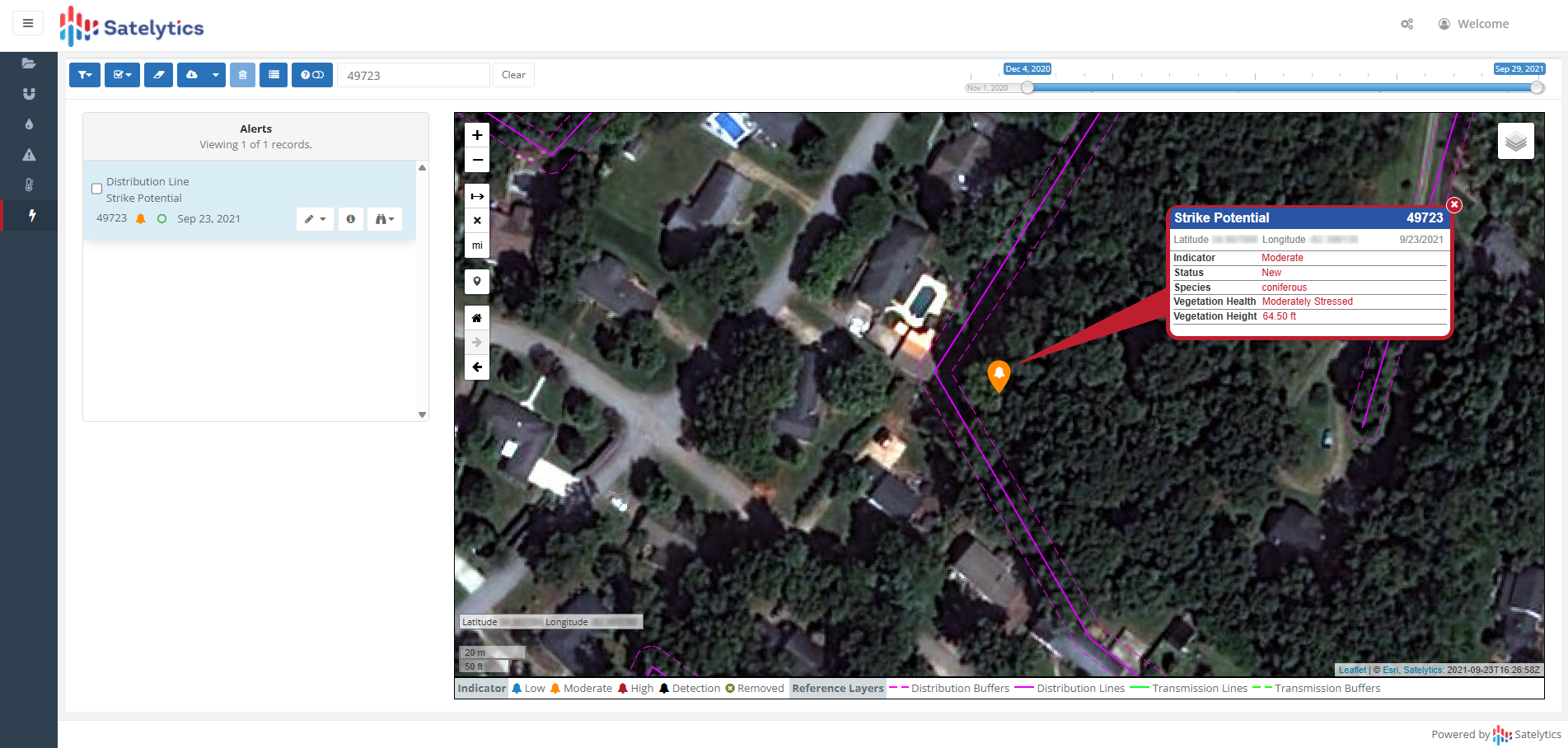
Caption: Satelytics’ vegetation monitoring product leverages Maxar’s very high-resolution satellite imagery to identify vegetation, like the coniferous tree in the above screenshot, that could possibly fall on electrical distribution networks. This alert enables a utility company to go into the field and mitigate specific vegetation issues instead of spending time monitoring the whole transmission line from a truck.
Satelytics will generate risk profiles of vegetation in and around customer assets using mono- and stereo-imagery collections from the Maxar constellation, including the recently launched WorldView Legion satellites. This solution will lean on Maxar’s collection capability of 6 million sq km of capacity per day, which significantly outpaces any other commercial provider.
Monitoring vegetation growth along utility lines or pipelines with Maxar’s 30 cm-class resolution satellite imagery and Satelytics’ value-added insights allows an energy company to prioritize sending ground crews to specific locations that are known to need trimming maintenance instead of having ground crews drive the entire lengths of lines, which can be hundreds of miles in distance. This targeted vegetation maintenance allows the energy company to reduce search time and increase efficiency of field crews, proactively identify and address potential threats outside the immediate corridor, verify completed work and optimize contractor management, and improve overall grid reliability by reducing vegetation-related outages.
-
“Maxar’s recently expanded capacity with the new WorldView Legion satellites creates new opportunities for us to reliably collect fresh, very high-resolution satellite imagery along our customers’ rights-of-way to analyze for vegetation encroachment. Our customers will benefit from the high-quality of Maxar’s imagery as value-added products like our vegetation risk assessments improve with better input data.”
— Sean Donegan, President and Chief Executive Officer of Satelytics
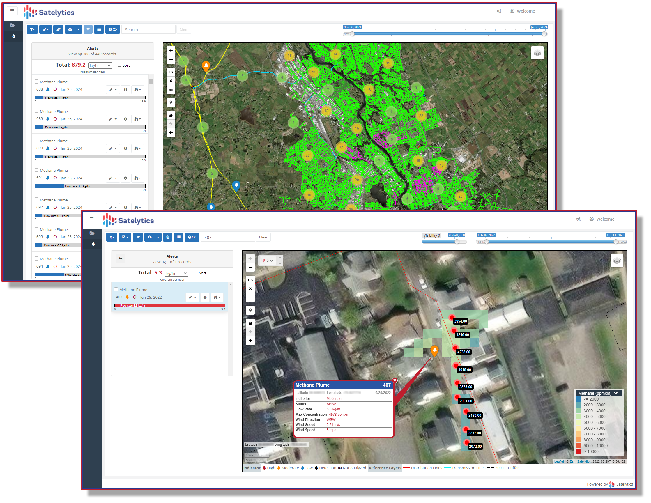
Producing methane detection alerts
Maxar’s WorldView-3 satellite hosts a shortwave infrared (SWIR) sensor that collects imagery in wavelengths outside what the human eye can see. Satelytics uses this SWIR sensor to create a methane detection and measurement product for energy companies. Duke Energy’s Piedmont Gas division, a local distribution company that operates in the Midwest and Southeast U.S., uses Satelytics’ methane solution to improve operational efficiency, safety and reporting by quickly finding leaks, repairing them and reducing emissions across a five-state service territory. Since the beginning of 2022, Duke Energy has reduced recordable leaks by over 85% using Satelytics’ solution. To learn more about Satelytics’ methane detection and quantification alerts, read their blog post.
-
“Satelytics has been innovating with Maxar’s very high-resolution satellite imagery for nearly a decade, and we’re excited to see them expand their offerings to include vegetation management for utilities. The quality, currency and accuracy of our data enables use cases that require precision to make informed decisions and Satelytics is taking it a step further with their energy industry-focused products.”
— Todd Surdey, SVP and GM of Enterprise at Maxar
Geospatial insights for informed monitoring and mitigation
The combined power of Maxar’s high revisit, very high-resolution satellite imagery and Satelytics’ AI-driven algorithms provides energy companies with early detection geospatial insights and alerts that enable informed decision-making and minimize environmental risks.
About Satelytics
Satelytics is a software company producing geospatial analytics for early detection, location and — in many instances — quantification of our customers’ most pressing challenges. The Ohio-based company uses science, software, and technology to deliver valuable services to customers to identify problems before they become disasters – environmentally, financially, or otherwise.
About Maxar Intelligence
Maxar Intelligence is a leading provider of secure, precise geospatial insights. Operating the most advanced commercial Earth observation constellation in orbit, we use the power of very high-resolution satellite imagery and software technology to deliver mission success on Earth and in space. Our secure, AI-powered products and services deliver ground truth in near real-time to keep nations safe, improve navigation, protect our planet, speed up disaster response and more. For more information, visit www.maxar.com.
Media Contact:
Michele Nachum
Firecracker PR
michele@firecrackerpr.com
Photos accompanying this announcement are available at
https://www.globenewswire.com/NewsRoom/AttachmentNg/223f51a2-25c9-4d75-b653-4eb05608a42d
https://www.globenewswire.com/NewsRoom/AttachmentNg/f28ffb1d-70d8-4426-8d43-c3604a6a0eea

![]()
Satelytics’ Vegetation Monitoring
Satelytics’ vegetation monitoring product leverages Maxar’s very high-resolution satellite imagery to identify vegetation, like the coniferous tree in the above screenshot, that could possibly fall on electrical distribution networks. This alert enables a utility company to go into the field and mitigate specific vegetation issues instead of spending time monitoring the whole transmission line from a truck.
Satelytics’ Methane Solution
Satelytics’ methane solution analyzes Maxar’s WorldView-3 high-resolution SWIR imagery to detect and measure small urban methane leaks from a local distribution network.
Legal Disclaimer:
EIN Presswire provides this news content "as is" without warranty of any kind. We do not accept any responsibility or liability for the accuracy, content, images, videos, licenses, completeness, legality, or reliability of the information contained in this article. If you have any complaints or copyright issues related to this article, kindly contact the author above.
